Introduction to geocoding
Geocoding is the process of assigning a geographic coordinate – in particular a latitude and longitude, to your records. If you want to visualise your customer data it must first be geocoded. In the earlier tutorial we used data which had already been geocoded, but this may not be the case with your own data.
ODL Studio includes three different and 100% free solutions for geocoding, suitable for different countries and locations:
- Batch geocoding by postcode using the Geonames free postcode database.
- Interactive geocoding by address using OpenStreetMap's Nominatim server.
- Manual geocoding by placing, adding or moving a point using the show map component. See the earlier tutorial for details on how to do this.
Additionally, as your data is held exclusively in an Excel file, you can use one of a number of commercial paid-for online services to geocode your data. Just google geocode excel sheet to find a number of services.
Geonames maintains a database of free worldwide postcode data and a component is available in ODL Studio to geocode a table using this database. Different countries differ in the quality and resolution of freely available postcode data. In the United Kingdom each postcode covers a very small area – perhaps 15 houses – and this data is freely available. Geocoding by free postcode data is therefore is a very good solution for the UK. In contrast other countries may not be available in the Geonames database or have low resolution postcode data. Use the following table to check the available data for your country and based on this decide whether the free Geonames database is appropriate for yourself or not:
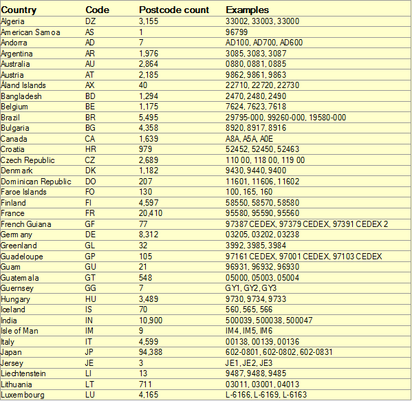
Counts of postcodes by country in the Geonames free database (countries A-L), version of database circa Jan 2014.
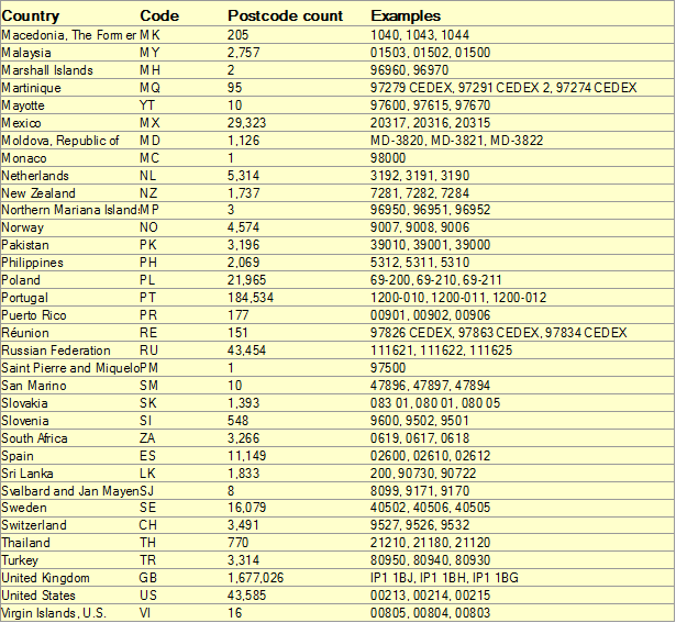
Counts of postcodes by country in the Geonames free database (countries M-Z), version of database circa Jan 2014.
