Repost from linkedin - Maximise your sales territory potential using open source software
Posted 08 Jul 2014
Reposted from linkedin....
Are you missing potential sales because your sales team doesn't have the resources to effectively pursue new leads? Or are you losing valued customers because your team doesn't have the time to properly maintain established customer relationships?
If the answer is yes to either, then you should ask yourself if your sales team is organised as efficiently as possible. A customer base requiring frequent visits is usually best serviced using defined sales territories - where individual members of your sales team service their own geographic area. However poor sales territory design brings a host of problems:
- Customers may not be given enough attention - and eventually lost - if your salesperson has more work than they can handle.
- Time and money will be lost and extra carbon dioxide emitted driving wasteful extra miles if you don't have compact territories. Is your sales team green?
- Team morale can be damaged if the distribution of sales opportunities or workload across sales territories is deemed unfair.
Clearly both sales and workload must be considered when balancing or aligning sales territories. A well-balanced sales territory has enough sales to cover its salesperson’s salary but cannot have more work than they can reasonably do.
Territory design software
Effective sales territory design and management (sometimes called territory alignment) requires good IT support. In particular you need interactive sales territory mapping which lets you easily reassign geographic areas or individual customers from one salesperson to another, and see how territory shape and key statistics change.
Surprisingly, although such software is conceptually very simple, it can still be very expensive. Current systems can cost thousands of dollars or pounds (see more), far beyond the reach of the IT budgets of many small and medium sized enterprises.
These systems are all based on a closed-source proprietary software model - where only the developers can modify or update the software and users must pay to use it. In contrast, open source software is free and may be redistributed or modified by anyone. This can make it easier to customise software to specific business requirements. The cost of creating open source software is primarily met by the developers selling customer support. The open source software movement has grown significantly in recent years, expanding rapidly into areas of business software - such as customer relationship management and enterprise resource planning - which traditionally have been dominated by expensive proprietary software. Following this trend, Open Door Logistics - a company specialising in open source software for transport logistics - have released the first open source solution for sales territory management, Open Door Logistics Studio.
ODL Studio builds upon many other great open source software projects and open data to deliver a fully-featured territory design, management and mapping system at no cost. ODL Studio's philosophy is to keep things as simple as possible. It works off an Excel spreadsheet as most analysts and sales managers will be comfortable with formatting and preparing Excel data. Here again, we have quality open source alternatives - OpenOffice and LibreOffice can be used just as easily as Excel to prepare your data for ODL Studio.
There are several steps to successful to territory design and mapping using ODL Studio.
Design territories using customer points or aggregated by geographic area?
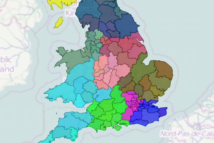
Typically sales territories are designed by aggregating key statistics to a geographic area and then using these areas as building blocks. For example, in the USA you might want to aggregate by state and then assign each salesperson to one or more states. Usually in the UK you would aggregate by postcode area (e.g. GL) or if more detail was required, postcode district (e.g. GL51). In Australia you could use local government area / shire or even four-digit postcode area.
In some cases however, aggregated sales territory design may not be the best choice. If your customer base is dominated by a small number of high-value customers, with each salesperson only managing at most ten or twenty each, you may want to design territories based directly on customer locations. Having greater visibility of individual customers in the territory design process will help ensure their needs are best met. In contrast, if your sales are dominated by a large number of small-turnover customers, then aggregation is clearly needed to simplify the territory design process.
Sales territory design using customer points
If you design your sales territories using customer points, then in your Excel sheet you eventually want to record the assigned salesperson - perhaps as a territory number - against each individual customer record. The first step is to assign latitude and longitude coordinates to each customer, corresponding to the location your salesperson will typically visit. This is called geocoding.
ODL Studio lets you geocode customers by postcode or zipcode using the excellent freeGeonames postcode database. The amount and quality of free data varies between countries. If free data does not meet your needs there are a variety of inexpensive online services for geocoding Excel-based data. Alternatively for a small number of customers you could geocode using ODL Studio's integration to another free data source - OpenStreetMap'sNominatim address-based geocoding. Once geocoded, use ODL studio to view your customers on an interactive map, which makes use of more open data - OpenStreetMap map image tiles.
For each customer record you should prepare sales and workload numbers. To estimate workload, use your sales team's historic records of customer visit frequency, visit duration and mileage. You will use these figures when constructing the territories, however you could also use them within a geographic analysis of your customer base by, for example, making customer points appear larger on the map for bigger customers.
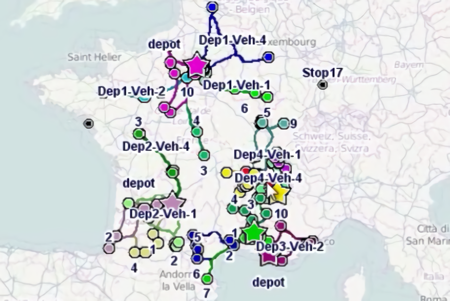
Open Door Logistics provides a series of tutorials giving step-by-step configuration instructions for a variety of customer mapping, territory design and territory mapping scenarios. Following these, set the interactive map to colour your customer points by their territory number and set-up barcharts to display the sales and workload distribution across your territories. Then use the map's territory painter mode to assign customers to territories, simply by dragging the mouse over an area of the map:

The barcharts automatically update when you modify your territories, giving instant feedback when balancing sales and workload. When you've finished, save your spreadsheet and either feed this back into your CRM or use ODL Studio to create sophisticated HTML, PDF or Word reports. The reports can be customised using another great open source product - Jaspersoft Studio.
Sales territory design aggregated by geographic areas
The first step in sales territory design with geographic aggregation is deciding what type of geography to base the aggregation on. Start simple and choose a coarse level of aggregation - for example states in the USA or postcode areas in the UK. Only use a more detailed level if and when you really need it. Here again, open data here is your friend. ODL Studio supports building blocks in shapefiles, a popular format for geographic data. Shapefiles for many different types of geographic area and countries are freely available from websites such as:
Open Door Logistics also provide approximate UK area, district and postcode boundaries for free.
After importing the building blocks into ODL Studio, aggregate your customer sales and workload numbers to the blocks. Firstly link each customer to the geographic block in which it is physically located (ODL Studio has functions to help you). Next use an ODL Studio update query to sum the sales and workload for each block from its customers. Finally, following thestep-by-step tutorials, set-up the interactive map to colour the blocks by their territory and barcharts to show sales and workload across all territories.
Now, as with points-based territory design, design your sales territories using the interactive map's territory painter mode and balance by checking against the barcharts. This YouTube video shows the design process for US states, UK postcode areas and districts and Australian local government areas.

Long-term sales territory management
Optimised territories are not permanently fixed. Over time sales or workload will naturally grow in some regions and fall in others, creating in-balance. You should regularly review your sales territories and adjust them as needed. To adjust existing territories just pre-fill the territory number field in your Excel with your current assignment and then follow the territory design process as normal.
If you'd like more information on ODL studio go to www.opendoorlogistics.com or download it at www.opendoorlogistics.com/downloads.